Devon Coast-to-Coast 2016
July 16-17th 2016
99 mile ride
Gain - 5280 ft
For my birthday this year I decided I wanted to tackle the Devon Coast-to-Coast cycle route. This goes from Ilfracombe to Plymouth (or vice-versa) and for us was 99 miles long. The route we used was Sustrans Route 27, with a couple of mini diversions to avoid "Mountain Bike Options".
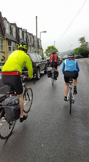
We were a group of four on mainly road bikes, self supported via panniers and pubs! Logistics-wise I organised for us to have a transfer from Plymouth to Ilfracombe on Friday night, enabling us to cycle back to our cars. This, combined with it being the first day of the summer holidays for many, made for quite a late Friday night after a journey totaling 8 hours and numerous cups of coffee (I don't even like coffee)!.
Day 1 - Ilfracombe to Okehampton
58 miles
After our late night we had a fairly leisurely start on Saturday, leaving at around 9 am. Our legs were shocked into action by a couple of short but extremely steep hills to leave Ilfracombe, I was certainly glad we weren't tackling the downhill version of these. Once out of the town we were straight onto an off-road bike path which seemed to have a reasonable surface, but caused us a puncture just 1.5 miles in. By this time we were fairly high and in a fair amount of cloud cover, so there was no view to admire whilst a fix was made, which was disappointing.
We followed the bike path at a steady climb, popping out where the route divides for one of it's trail options via Morthoe and Woolacombe. Having actually done that stretch before I sensibly chose for us to stay up high on a pleasantly undulating road. the clouds were gradually thinning, and just before our descent into Braunton we got a stunning glimpse of Morte Bay.
In Braunton we picked up the Tarka trail, which mostly utilises a disused railway to provide 20 miles of pancake flat, surfaced path. This took us past the Royal Marine Base (of particular interest as I had just watched the Royal Marine Commando School tv programme) and then around the River Taw estuary, which was empty of water but provided some fantastic, sandy views. The track then followed the river Torridge right through to Torrington where we stopped at the Puffing Billy cafe for some lunch.
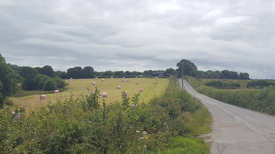
This lunch was needed as the next section of track took us on a steady uphill gradient (combined with rapidly deteriorating surface) to a summit just past Little Torrington, where we were rewarded with a similarly poorly surfaced downhill. At Petrockstowe (about 38 miles in) we left the Tarka trail for good and headed off onto some pleasingly quiet country roads. My bum and tyres were very grateful for this - I even enjoyed the undulations to start with too. After a while I do find cycling on a flattish trail a little uncomfortable as it gives little opportunity for natural shifts in position.
We admired many of the local villages, picking up some fresh eggs and briefly stopping at the Hatherleigh monument to admire the view at the highest point of our cycle ride (or so we thought!). By the monument there was an informative sign which showed us that our destination, Okehampton, lay in the base of the next valley. With this in mind we set off downhill, and before long reached the town. Unfortunately what I hadn't accounted for was that our lodgings at the YHA were actually on the other side of the valley, so the day ended with much puffing and grunting up a steep 300 ft hill! This did make the cold cider that greeted us even more rewarding though....
Day 2 - Okehamption to Plymouth
41 miles
Although a comfortable hostel (we had our own room with bathroom), very little sleep was had by myself on Saturday night as it was extremely warm. However, I did wake (at 4.15 am) excited about both the fresh eggs from yesterday and the day's cycle ahead.
The eggs were as good as anticipated (less so my bottle of water which had grown a lot of black mould overnight) and we set off at a similar time to the day before, knowing we had a shorter day ahead of us. My bum seemed less excited about the day ahead and it took me a good few miles to coax it onto my saddle (I currently ride ISM Adamo Prologue - comfy but the sit bones can take a bit of a beating, especially in a more upright "touring" position). Thankfully today's route started on the Granite Way, another stunning section of off-road trail with a number of viaducts which only improve the vistas.
Ten miles in at Lydford we rejoined the roads, which quickly got very main for a fast diversion around the route at Peter and Mary Tavy (I had been told that the 27 gets very muddy here). After turning back onto the route we bumbled about the side of a valley before a very very steep descent into Tavistock. Tavistock seemed a nice little town (much better than I had anticipated) but the bike route did that frustrating thing of desperately keeping you off what seemed to be fairly quiet roads, which ended up in a lot of faffing crossing roads etc. for not much gain.
After Tavistock we picked up the route again for another long off-road stretch which was a pleasant surprise. Also a surprise were a couple of longish, pitch-black tunnels. I remember being a little confused whilst creating the track, as at about 21 miles in the route disappeared, and then reappeared in the middle of a field! This turned out to be one of the tunnels, which made perfect sense!
Horrabridge provided us with a "Horra" of a climb (geddit?), and for the first time I wasn't appreciating the fact we were off road as the track was so narrow it made traversing impossible (my bike is NOT geared for carrying panniers). Determined to keep up my record of not walking up any hill on this particular ride however, I made it up onto the top, which was very common-like in appearance, and looked like a lovely place for a Sunday afternoon stroll. A brief argument about the route later, we started descending through Yelverton, where the route kinked slightly and carried on descending on a lovely new surface. It then carried on, and on, and on, and on descending, to the point where I started to feel rather sorry for the people coming up (it was shaded by trees but nevertheless a not day).
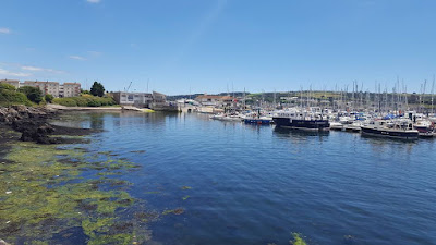
Seven (yes seven!) miles of descent later (my longest downhill yet) we reached the outskirts of Plymouth, with the track getting exceptionally busy. Once we met the River Plym (the name "Plymouth" makes complete sense to me now!) we took a quick detour to Saltram, a National Trust property. This was obviously for food rather than to admire any old buildings, and a fish finger sandwich and large ice cream later we set off for the final stretch.
Entering any city has its ups and downs (although thankfully not too literally in this case) but based on our drive into Plymouth, the cycle route did show off the best of the city. It followed the coast around a harbour and right around to Devil's Point, where we had parked. We were briefly held up waiting to cross a moving bridge, but I think that that only added to the character of what was overall a fantastic ride.


99 mile ride
Gain - 5280 ft
For my birthday this year I decided I wanted to tackle the Devon Coast-to-Coast cycle route. This goes from Ilfracombe to Plymouth (or vice-versa) and for us was 99 miles long. The route we used was Sustrans Route 27, with a couple of mini diversions to avoid "Mountain Bike Options".
We were a group of four on mainly road bikes, self supported via panniers and pubs! Logistics-wise I organised for us to have a transfer from Plymouth to Ilfracombe on Friday night, enabling us to cycle back to our cars. This, combined with it being the first day of the summer holidays for many, made for quite a late Friday night after a journey totaling 8 hours and numerous cups of coffee (I don't even like coffee)!.
Day 1 - Ilfracombe to Okehampton
58 miles
After our late night we had a fairly leisurely start on Saturday, leaving at around 9 am. Our legs were shocked into action by a couple of short but extremely steep hills to leave Ilfracombe, I was certainly glad we weren't tackling the downhill version of these. Once out of the town we were straight onto an off-road bike path which seemed to have a reasonable surface, but caused us a puncture just 1.5 miles in. By this time we were fairly high and in a fair amount of cloud cover, so there was no view to admire whilst a fix was made, which was disappointing.
We followed the bike path at a steady climb, popping out where the route divides for one of it's trail options via Morthoe and Woolacombe. Having actually done that stretch before I sensibly chose for us to stay up high on a pleasantly undulating road. the clouds were gradually thinning, and just before our descent into Braunton we got a stunning glimpse of Morte Bay.
In Braunton we picked up the Tarka trail, which mostly utilises a disused railway to provide 20 miles of pancake flat, surfaced path. This took us past the Royal Marine Base (of particular interest as I had just watched the Royal Marine Commando School tv programme) and then around the River Taw estuary, which was empty of water but provided some fantastic, sandy views. The track then followed the river Torridge right through to Torrington where we stopped at the Puffing Billy cafe for some lunch.
This lunch was needed as the next section of track took us on a steady uphill gradient (combined with rapidly deteriorating surface) to a summit just past Little Torrington, where we were rewarded with a similarly poorly surfaced downhill. At Petrockstowe (about 38 miles in) we left the Tarka trail for good and headed off onto some pleasingly quiet country roads. My bum and tyres were very grateful for this - I even enjoyed the undulations to start with too. After a while I do find cycling on a flattish trail a little uncomfortable as it gives little opportunity for natural shifts in position.
We admired many of the local villages, picking up some fresh eggs and briefly stopping at the Hatherleigh monument to admire the view at the highest point of our cycle ride (or so we thought!). By the monument there was an informative sign which showed us that our destination, Okehampton, lay in the base of the next valley. With this in mind we set off downhill, and before long reached the town. Unfortunately what I hadn't accounted for was that our lodgings at the YHA were actually on the other side of the valley, so the day ended with much puffing and grunting up a steep 300 ft hill! This did make the cold cider that greeted us even more rewarding though....
Day 2 - Okehamption to Plymouth
41 miles
Although a comfortable hostel (we had our own room with bathroom), very little sleep was had by myself on Saturday night as it was extremely warm. However, I did wake (at 4.15 am) excited about both the fresh eggs from yesterday and the day's cycle ahead.
The eggs were as good as anticipated (less so my bottle of water which had grown a lot of black mould overnight) and we set off at a similar time to the day before, knowing we had a shorter day ahead of us. My bum seemed less excited about the day ahead and it took me a good few miles to coax it onto my saddle (I currently ride ISM Adamo Prologue - comfy but the sit bones can take a bit of a beating, especially in a more upright "touring" position). Thankfully today's route started on the Granite Way, another stunning section of off-road trail with a number of viaducts which only improve the vistas.
Ten miles in at Lydford we rejoined the roads, which quickly got very main for a fast diversion around the route at Peter and Mary Tavy (I had been told that the 27 gets very muddy here). After turning back onto the route we bumbled about the side of a valley before a very very steep descent into Tavistock. Tavistock seemed a nice little town (much better than I had anticipated) but the bike route did that frustrating thing of desperately keeping you off what seemed to be fairly quiet roads, which ended up in a lot of faffing crossing roads etc. for not much gain.
After Tavistock we picked up the route again for another long off-road stretch which was a pleasant surprise. Also a surprise were a couple of longish, pitch-black tunnels. I remember being a little confused whilst creating the track, as at about 21 miles in the route disappeared, and then reappeared in the middle of a field! This turned out to be one of the tunnels, which made perfect sense!
Horrabridge provided us with a "Horra" of a climb (geddit?), and for the first time I wasn't appreciating the fact we were off road as the track was so narrow it made traversing impossible (my bike is NOT geared for carrying panniers). Determined to keep up my record of not walking up any hill on this particular ride however, I made it up onto the top, which was very common-like in appearance, and looked like a lovely place for a Sunday afternoon stroll. A brief argument about the route later, we started descending through Yelverton, where the route kinked slightly and carried on descending on a lovely new surface. It then carried on, and on, and on, and on descending, to the point where I started to feel rather sorry for the people coming up (it was shaded by trees but nevertheless a not day).
Seven (yes seven!) miles of descent later (my longest downhill yet) we reached the outskirts of Plymouth, with the track getting exceptionally busy. Once we met the River Plym (the name "Plymouth" makes complete sense to me now!) we took a quick detour to Saltram, a National Trust property. This was obviously for food rather than to admire any old buildings, and a fish finger sandwich and large ice cream later we set off for the final stretch.
Entering any city has its ups and downs (although thankfully not too literally in this case) but based on our drive into Plymouth, the cycle route did show off the best of the city. It followed the coast around a harbour and right around to Devil's Point, where we had parked. We were briefly held up waiting to cross a moving bridge, but I think that that only added to the character of what was overall a fantastic ride.


Comments
Post a Comment